Mining surveying
Discover our capabilities in the field of modern surveying and geological servicing of mining equipment!
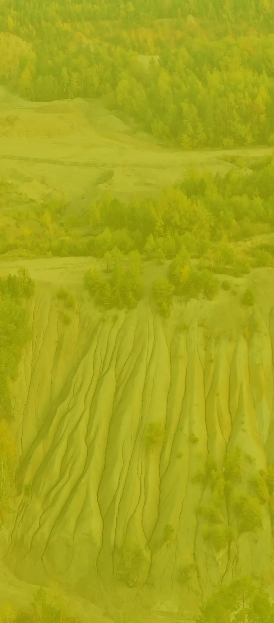
Comprehensive tasks - from geological documentation of the deposit, through mining operations, to reclamation. In activities using the latest measurement methods from drones, laser scanners and bathymetric unmanned floating systems. and related activities are available – in our ranks that connect with 3 mining surveyors with access, originating from underground, open-pit and borehole mining. The team of surveyors is supported by a young, but experienced and developing team of specialists.
Change doesn't have to be this difficult
We are aware of the fact that changing the company performing measurement supervision at a mining plant is a difficult step, which is why we are flexible in preparing the offer. Due to this fact - if you are not yet ready for our team to fully take over the service, but want to significantly increase the quality and safety of measurements, hybrid solutions are possible. This may involve, for example, 3D Format taking over the measurement process and updating mining maps, while leaving the rest of the tasks to your experienced surveying and geological department. We have been using this solution for several years, including: with KOSD Niemodlin for their rock aggregate mines and gravel pits.
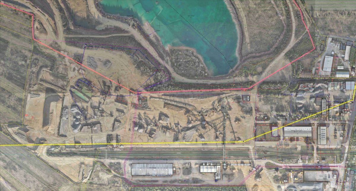
We perform our measurements in the field of mining geodesy throughout Poland and abroad. We have already been trusted by several dozen mining plants, mainly in the province. Lower Silesia, Silesia, Łódź, Lesser Poland and Świętokrzyskie. The location of our office at the intersection of the A1 and A4 motorways in Gliwice allows us to reach any part of the country in a short time.
Modern work tools, simple solutions
3D models, point clouds, orthophotomaps are some of the products we provide. Each new technology can be overwhelming - a change in approach, a different type and size of resulting files, and many other factors. For this reason, we try to familiarize our clients with the new type of data by providing convenient web applications (click on the link to see an example) or processing large files into accessible formats. How do we perform these measurements then?
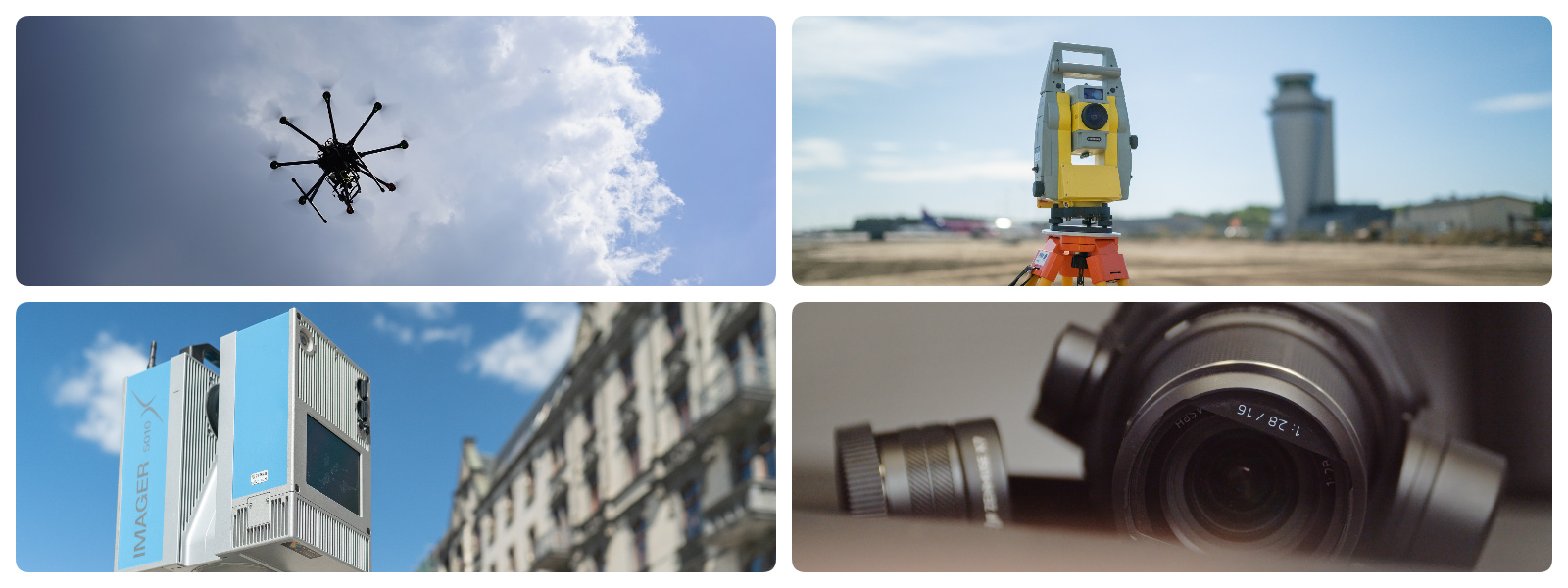
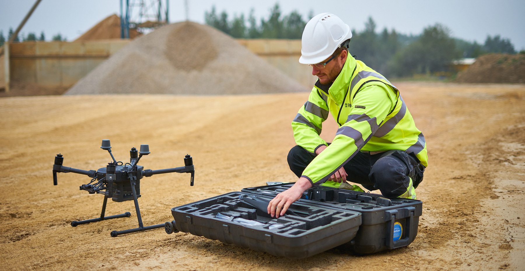
- Drones, i.e. the so-called unmanned aerial vehicles - our pilots carry out raids on multi-hectare mining excavations, mapping them in a photorealistic way with an accuracy of single centimeters. As a result of the measurements, orthophotomaps and 3D models are created. Here we have 2 technologies available:
Photogrammetry – a technique that allows mapping the topography of the area based on a large number of photos taken. The measurement takes place indirectly after processing the photos into a 3D point cloud- Airborne laser scanning (so-called LiDAR) - a technology that allows direct measurement of point coordinates "from the air" with the possibility of obtaining information about terrain elevations even in the presence of trees and dense vegetation
- Terrestrial laser scanners - if accuracy at the millimeter level is required and you are planning, for example, reconstruction of the infrastructure of a processing plant, we use a tool that allows direct measurement of millions of points within a few minutes
- An unmanned bathymetric vessel - a device that allows measuring the depth of a water reservoir and precisely mapping its bottom
- Thermal imaging cameras - thanks to a high-resolution camera installed on the drone operating in the near infrared range, it is possible to identify any anomalies occurring at the processing plant, which are reflected in the temperature difference. An example would be a worn roller bearing. overheating gears or belt conveyor motors
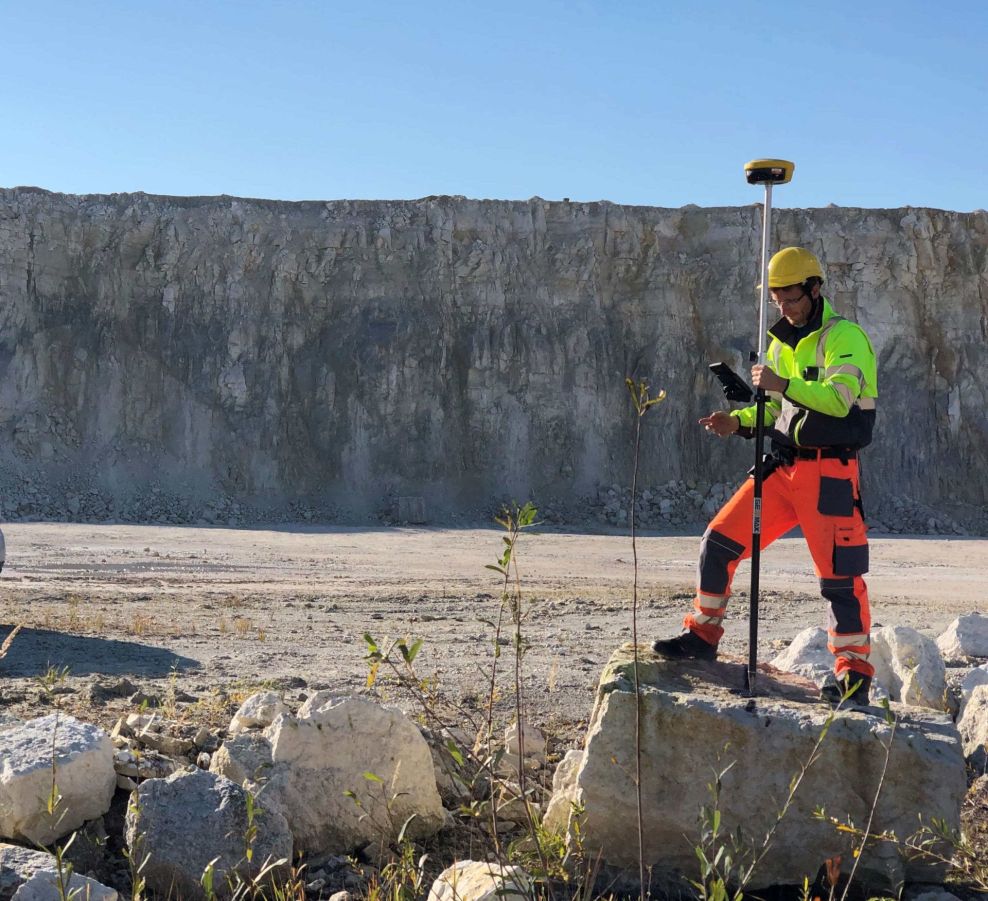
- Classic surveying equipment - despite the use of the latest technologies, GPS receivers, total stations and levels that have been used by surveyors for years are no stranger to us, so if the situation requires it, we also use these solutions
But how do these modern technologies relate to the Geological and Mining Law?
They are in line with the regulations, even though the executive act to the Act - the Regulation of the Minister of the Environment of December 22, 2011 on surveying and geological documentation does not make direct reference to photogrammetry, laser scanning or even GPS measurement techniques. Multiple inspections by inspectors of District Mining Offices in various voivodeships where our mining plants are located (Lower Silesia, Łódź, Silesia) confirmed that the photogrammetric measurements we carried out relating to the horizontal and height of the state matrix were performed properly, and there were no comments regarding the measurement techniques used and their documentation methods. Moreover, OUG inspectors expressed their satisfaction with the use of the photogrammetry technique in the measurement of mining excavations due to the awareness of data transparency, clarity, accuracy and, above all, safety of measurements. For example, a dozen or so years ago there was no option - a team of surveyors had to physically measure a mining excavation, lasting up to several days, never being sure whether when a GPS pole or a mirror was placed, the rock masses would not detach or the mining slope would collapse. If measurements are made using non-invasive techniques, the mining plant operations manager (KRZG) - who is responsible for people staying in the mining area - can rest easy. Instead of several days of measurement for a medium-sized rock aggregate mine, we have an inventory lasting several minutes, made with a drone moving fully autonomously, and the pilot only observes its operation in a safe place that does not disturb the operation of the mining plant. We consult our experience in the use of unmanned techniques on an ongoing basis with employees of the State Mining Office, jointly paving the way for solutions that are more beneficial for each party - both for the mining entrepreneur, officials and for us, contractors.
Measurement is not everything
Our work in open-pit mines is not always related to surveying services. We often start our adventure with mining plants with more or less advanced monitoring of the operation, movements of rock or earth masses and precise measurements of the volume of reserves. Currently, there is no better way to settle with contractors work related to, e.g. removal of overburden, than cyclical photogrammetric raids, which result in a precise value of the loss. Full control of the raw material extraction process allows you to optimize the operation of a mining plant by precisely determining the amount of extracted minerals, mining waste or finished product at the processing plant, and then identifying those places where there are differences from the expected values.

Our specialty in this area is precise volumetric measurements using drones. To improve and automate this process, we have created our own, unique volume measurement system - VolumeMonit. The solution allows for very quick provision of information on the amount of inventory collected at a processing plant, excavation site or railway siding and verification of inventory levels with an accuracy of 1%. Since nowadays drone flights are very convenient and simple, we decided on a revolution - you take the measurement at any time convenient for you, and we do what we are best at - data processing and performing accurate calculations.

Presentation of data
In addition to providing the client with the right documentation, we ensure that the spatial models we acquire can be used as widely as possible. We always try to choose the optimal way of presentation and transfer of data. We provide, among others:
- Internet platform with access to 3D model, orthophoto-map or DSM model with the possibility to browse, make measurements and cross-sections or even apply your own layers or design
See an example - Printing models on 3D printers
- Virtual flights through 3D models in mp4 files.
See an example - 3D models on the Sketchfab platform
See an example
Our products
As a result of appropriate data processing, we can offer several products - both for full 3D and classic 2D work. These are, among others, orthophoto-maps, projections, cross-sections, longitudinal profiles and various thematic maps.
Point cloud
A point cloud is a multi-million point set that is a geometric representation of a scanned object.
Clouds are acquired either indirectly (photogrammetry) or directly (3D laser scanning). There is a possibility to provide a cloud that is a combination of both technologies, which allows for full imaging of a scanned object.
Point clouds are usually so dense that they appear to form a continuous surface. The density of a point cloud depends on the class of scanner, its accuracy settings, and the distance from the object being scanned. Each point has a colour assigned to it, which makes it easier to identify the reconstructed objects in the cloud. Unlike the photogrammetry technique, the acquired point cloud has a scale, so measurements can be performed on it immediately without the need for fitting.
Upon client’s request, the cloud is provided in Polish Coordinate System 2000. Available data exchange formats include: LAS, LAZ, PLY, XYZ, RCP and RCS. Point cloud can be conveniently viewed and measured in Autodesk Recap software. Additionally, it can be loaded into AutoCAD, Microstation, Cyclone or ArcGIS software.
Application: Design, architectonic, visualization and planning purposes

3D model with superimposed texture
3D model with superimposed texture: OBJ, STL, PLY, FBX and 3D PDF.
It is possible to load the file into programs such as Revit, Inventor, Meshmixer, Infraworks, 3D Studio Max and Sketchup and print it on a 3D printer.
Application: Visualization and planning purposes

Orthophotos
Orthophoto-map is a cartometric image acquired as a result of processing a photo taken by an unmanned aerial vehicle (BSP, drone). It is a comprehensive source of knowledge about a given space.
The image obtained from the drone is characterized by a high resolution of the field pixel (at the level of 1 cm), which allows us to identify even the smallest elements of the infrastructure. In contrast to the aerial photo, orthophoto-map has a uniform scale for the entire surface of flat field. The use of drones in surveying work enables the preparation of an orthophoto-map of a given area even of several hundred hectares. The product is georeferenced which makes it possible to read the map in the appropriate software and to make the project and add resources in the form of the basic or register map.
It is possible to load maps with accurate georeferencing into such programs as AutoCAD Map 3D, AutoCAD Civil 3D, Microstation and ArcGIS.
Uses: spatial planning, land registry modernization, environmental analysis, designing construction works, site visualization, detecting changes in the natural environment, creating documentation of natural disasters, quality control of maps and cartographic data

Numerical land coverage model
Numerical coverage model provides precise representation of the existing field, which generates a wide range of possibilities for analysis, comparison, calculation, design and spatial planning.
The available formats are: GEOTIFF, XYZ, LAS and LAZ. It is possible to import the file to AutoCAD Map 3D, AutoCAD Civil 3D, ArcGIS and Microstation.

Videos and photos with editing
Tworzymy filmy w dowolnej jakości – nawet do 4K. Dokumentacja video pozwala na precyzyjną inspekcję
We create films in any quality - even up to 4K. Video documentation allows for a precise inspection of a specific element. We also offer visualisations in the universal MPEG4 (MP4) format which enables a comfortable presentation of an object to a Client, investor or supervisory inspector. We offer taking a very large number of photographs (from several dozen to several thousand - depending on the size of an object) with a resolution of up to 36 MP.
The photos are in a customized format.
Application: Very detailed documentation of an object and its changes over time
We deliver films in MP4 or AVI format.
Application: Very detailed documentation of a specific component

Calculations of volume, area and length
The information is supplemented by an appropriate graphical presentation, authenticating the calculated value.
We use low-altitude aerial photogrammetry technique with the use of non-metric images. The technology involves processing digital images to a 3D point cloud, which is a spatial, finite representation of field consisting of points with coordinates X, Y, Z and the colour value of each point (pixels).
In order to calculate the volume of earthworks, we create numerical field models in the form of TIN (Triangulated Irregular Network) grid in AutoCad Civil 3D software.
The computational task is to compare the created numerical field models (TIN meshes). The difference between the 3D surfaces is obtained and then the values of excavations and embankments between the models are calculated.

Cross-sections and projections
An interesting product for documenting building structures is the orthometric projection.
It is a fully cartometric representation of a specific plane, e.g. a façade, a building front, an acoustic screen or a retaining wall. Saving to a TIFF file enables us to review an object in high resolution. Depending on the Client’s wish, cross-sections may be saved to CAD (DWG, DXF) or PDF files.
Application: Creating a clear architectural and construction inventory (mainly for planned renovations).

3D modelling
3D modelling is a process in which we use software to transform a mathematical representation of an object into a 3D model. The created object is called a three-dimensional model used in branches such as mining, industry, construction or architecture.
3D modelling facilitates communication of ideas, is used to create interactive positioning of objects or surfaces that represent the actual design. It provides control of the real condition with design parameters. It allows us to create a part of a physical object in a very fast time, so we can make analyses of physical properties and then update the model as needed.
Available data formats are: DWG, DXF, DGN, STP and others. Models (solids) are created by us on the basis of a point cloud to maximally facilitate the Client’s work in such programs as AutoCAD Civil 3D, Inventor, Revit or Archicad. Processed buildings, machines or pipe networks give the possibility to work comfortably in the environment familiar to the designer.

Online application - sharing 3D measurements
Our company offers data sharing on platforms such as Sketchfab and Cloud PIX4Dcloud, as well as YouTube.
Sketchfab
Sketchfab is a platform that allows us to publish our 3D models online. It uses WebGl technology, thanks to which we can view or share our files without having to install any plug-ins in our browsers.
PIX4D cloud
PIX4Dcloud is an online platform for mapping data acquired from photogrammetric air shots, tracking progress and documentation. It allows us to create 2D maps and 3D models from the received images. It enables distance, area and volume measurements, as well as virtual inspections of the area of interest. It generates elevation profiles and allows us to share the results with stakeholders.
