Photogrammetry and thermal imaging
Photogrammetry is a branch of science and technology that deals with reconstructing the three-dimensional shapes and sizes and mutual positions of various types of objects in a given area, using photographs.
In land surveying this technique is used to measure large (even up to several hundred hectares) and topographically complex surfaces in a very high resolution.
In land surveying this technique is used to measure large (even up to several hundred hectares) and topographically complex surfaces in a very high resolution. For our studies we use short-range ground photogrammetry and low-light photogrammetry with the application of unmanned aerial vehicles - drones. The combination of both techniques with the additional use of 3D laser scanning enables us to show also places inaccessible for drones, e.g. interiors of buildings. The studies are adjusted to the Polish Coordinate System 2000 so that they can be compared with the materials provided by the Centre for Land surveying and Cartographic Documentation, e.g. an orthophoto-map with a base or registered map or a point cloud with a contour map.
Advantages of land surveying surveys made with a drone
- Rapid measurement of large areas
- Obtaining precise data on plots and land for construction of various types of buildings and roads (precise model of a given area)
- Possibility of obtaining full information about the three-dimensional shape of the most complex fields (opencast mines, mounds etc.)
- Very high quality and resolution of images - they are precise and clear
- Large amount of data acquired
- A non-negotiable form of obtaining information
- Possibility to start the design process even before the map for design purposes is drawn up or before other land surveying materials are acquired
- Possibility of quick estimation of bill of quantity reliability (reduction of possible unforeseen costs)
- High accuracy of the studies - especially with a required large number of points to be measured (incomparable accuracy in relation to classical measurements, where we talk about the error at the level of 5%)
- Non-invasive and safe measurements - no need to interrupt production
- Possibility to measure in hard-to-reach areas
Drone shots - application
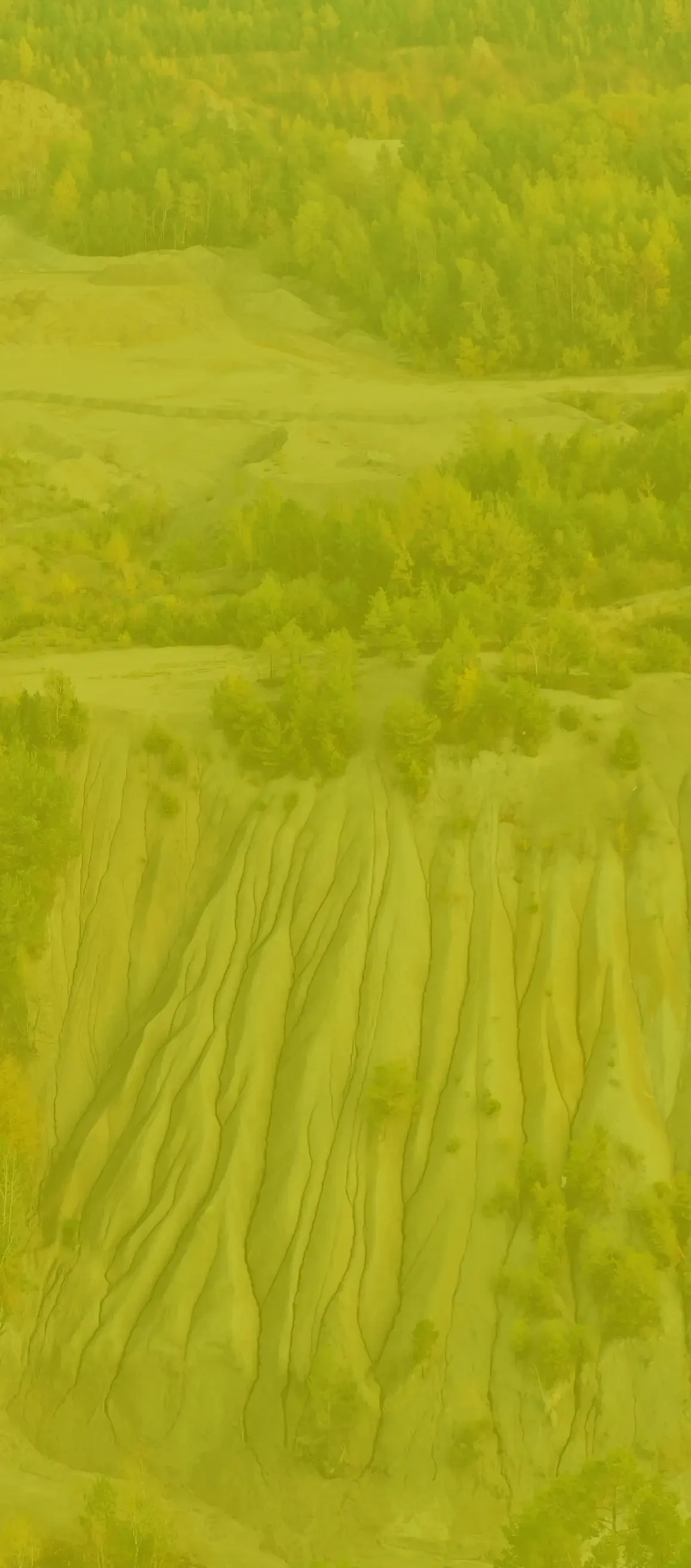
Photogrammetry with the use of drones is applied wherever measurement with classical methods is difficult or even impossible. It allows to acquire a quasi-continuous image of the field in the form of a 3D point cloud so dense that it gives the impression of a continuous surface. Thanks to processing of 3D point cloud to the numerical field model, e.g. TIN grid, we obtain material for engineering analyses, including most often precise volume calculations.
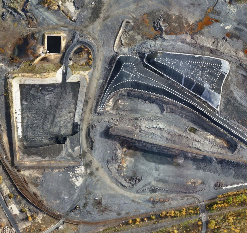
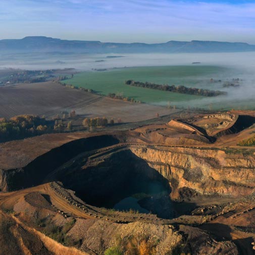
- Surface mining - photogrammetry using drones combined with measurement and land surveying services guarantees a completely new level of quality, accuracy and safety of measurements.
- Hard coal mining - inventory of coal and coke heaps and precise measurements of even the most extensive post-mining heaps.
- Construction - inventory measurements of linear and cubature structures, including mainly cyclical monitoring, allowing for tracking and documenting the progress of construction works.
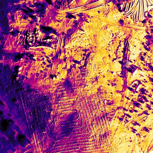
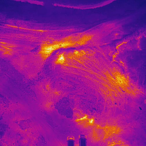
- Waste management - inventories of municipal, mining, metallurgical and other waste dumps in order to monitor the increase/surge in volume, study the capacity reserve volume or environmental condition. For this industry we also use 3D thermal imaging measurements. In the case of even the smallest thermal activity of a heap or a dump, it is possible to geometrically visualise the scale of the hazard and to determine the extent of spreading or disappearance.
- Calculations of the volume of loose materials and precise determination of the volumetric density factor - thanks to the development of an innovative method in cooperation with specialists from the Silesian University of Technology in Gliwice, we have a method for determining the volumetric density factor (bulk weight) with a precision several times higher than the method specified in the Polish Standard. We guarantee accuracy of material calculations at the level below 2%, which is confirmed by the signature of a certified surveyor or mine surveyor. Currently, we are carrying out a research and development project co-financed by European Funds entitled: "Automated system for precise volumetric measurements - VolumeMonit", which focuses on this subject.
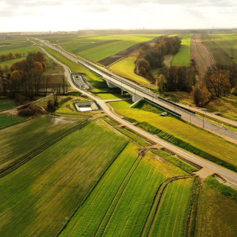
- Designing - both in the scope of road and railway construction and earth structures as well as cubature constructions. Orthophoto-maps make it possible to design on a substructure fully reflecting the actual state in the field, in the time before obtaining the map for design purposes, which significantly improves and accelerates the design process. On the other hand, point clouds allow for precise adjustment to the actual field or development. Moreover, we prepare concepts and designs of shaping of, among others, recultivated objects (mounds, settling ponds etc.) or earthworks.
- Estimation of Damage to crops by animals - thanks to the drone flight over the area destroyed by wild animals we can very precisely calculate the area and scale of damages and provide a farmer with information in an attractive form - e.g. as an application in a web browser. We also provide services of an authorised expert.
- BIM (Building Information Modelling) - drone flights allow for the creation of an information-rich spatial model of an object in the form of a point cloud, mesh grid or CAD model. With such data it is possible to integrate the data obtained from the existing object with the spatial design data and make the documentation conveniently available in the construction process conducted in accordance with the BIM methodology. The use of drone shots in this way is particularly important in road and railway construction, in the shaping of earth structures (embankments, reservoirs, storage yards) and in the operation of cubature construction sites. More applications can be found in the section on laser scanning (photogrammetry is often a very good complement).
- Inventories of historical buildings (architecture) - drone shots over historical buildings allow for a rich, photorealistic representation of a building in 3D, which allows for inventory of even the most complex elements (cornices, ornaments, architectural details), impossible to measure manually.
- Specialist inspections - the diversity of our surveying, photogrammetric and thermal imaging equipment as well as other tools allows us to undertake even the most complex orders, often not associated with land surveying. Due to our extensive network of contacts with specialists, engineers and scientists, we guide our clients to the right solution, which we implement in cooperation with relevant entities.
Presentation of data
In addition to providing the client with the right documentation, we ensure that the spatial models we acquire can be used as widely as possible. We always try to choose the optimal way of presentation and transfer of data. We provide, among others:
- Internet platform with access to 3D model, orthophoto-map or DSM model with the possibility to browse, make measurements and cross-sections or even apply your own layers or design
See an example - Printing models on 3D printers
- Virtual flights through 3D models in mp4 files.
See an example - 3D models on the Sketchfab platform
See an example
Drone shots in practice
Often, after the execution and presentation of the 3D model acquired by low-light photogrammetry technique, our customers talk about "field scanning", so it can be very surprising that there is no "scanner" on board the BSP. The only sensor used for data acquisition is a camera, integrated (or not) with a given drone.
Photogrammetry using non-metric images allows us to process them in such a way as to obtain a three-dimensional model of an object. How does it work? In simple terms, it is similar to how human eyes work. With a pair of eyes, we see in a spatial manner. Two eyes observe the same area from two different points. Our brain performs on the fly a kind of so-called land surveying forward slice, which consists in determining the spatial location of the observed point from afar. Similarly, by observing the same points from many different camera positions (several to a dozen or so shots of the same point on the image), we are able to reconstruct the shape of a given object. For the photos to be linked together, photogrammetric software searches for characteristic points on them, which in the further processing allows the photos to be linked together to create a grid.
Photogrammetric air shots are mainly implemented in autonomous mode. Thanks to the possibility of setting an appropriate longitudinal and transverse coverage between pictures, the system automatically triggers the camera shutter. Depending on the resolution of the sensor on board the BSP and the set flight altitude, we obtain the resulting value of a single field pixel - usually at the level of 1 to 5 cm. We also carry out specialised tasks in the field of bridge engineering, where it is possible to obtain a pixel size even below 1 mm, which allows, for example, the inspection and measurement of cracks on building structures.
Thermal imaging surveys
We perform thermal imaging scans using unmanned aerial vehicles, photogrammetry and laser scanning techniques throughout Poland and abroad. We have an experienced team and advanced measurement equipment. We ensure high quality of acquisition and analysis of thermal imaging data.
We perform thermal imaging scans in residential and industrial buildings, as well as in open spaces, such as post-mining mounds. We have advanced equipment to perform infrared measurements - a high-resolution 640x480 Zenmuse XT2 camera with a double lens (RGB + infrared), which allows for convenient juxtaposition of infrared images with images in real colours. The equipment of such quality makes it possible to perform photogrammetric thermal imaging studies, i.e. to generate 3D models and orthophoto-maps on which geometrically oriented temperature distribution can be observed.
We are able to quickly and accurately identify the sources of leaks and other faults without interfering with the walls of the building. This allows us to effectively and permanently eliminate the problem and, as a result, to optimise heating costs and avoid service expenses.
Advantages of thermal imaging measurements
- No interference with the building structure
- Quick detection of areas of heat loss
- High surveying accuracy
- Versatile application
Thermal imaging scans - applications
- Conducting energy audits in plants and production halls
- Checking the condition of the central heating system and the electrical system
- Assess the operation of machinery and equipment for possible overheating of bearings and other parts
- Airtightness testing of buildings
- Identification of causes of fungi and moulds
Our products
As a result of appropriate data processing, we can offer several products - both for full 3D and classic 2D work. These are, among others, orthophoto-maps, projections, cross-sections, longitudinal profiles and various thematic maps.
Point cloud
A point cloud is a multi-million point set that is a geometric representation of a scanned object.
Clouds are acquired either indirectly (photogrammetry) or directly (3D laser scanning). There is a possibility to provide a cloud that is a combination of both technologies, which allows for full imaging of a scanned object.
Point clouds are usually so dense that they appear to form a continuous surface. The density of a point cloud depends on the class of scanner, its accuracy settings, and the distance from the object being scanned. Each point has a colour assigned to it, which makes it easier to identify the reconstructed objects in the cloud. Unlike the photogrammetry technique, the acquired point cloud has a scale, so measurements can be performed on it immediately without the need for fitting.
Upon client’s request, the cloud is provided in Polish Coordinate System 2000. Available data exchange formats include: LAS, LAZ, PLY, XYZ, RCP and RCS. Point cloud can be conveniently viewed and measured in Autodesk Recap software. Additionally, it can be loaded into AutoCAD, Microstation, Cyclone or ArcGIS software.
Application: Design, architectonic, visualization and planning purposes

3D model with superimposed texture
3D model with superimposed texture: OBJ, STL, PLY, FBX and 3D PDF.
It is possible to load the file into programs such as Revit, Inventor, Meshmixer, Infraworks, 3D Studio Max and Sketchup and print it on a 3D printer.
Application: Visualization and planning purposes

Orthophotos
Orthophoto-map is a cartometric image acquired as a result of processing a photo taken by an unmanned aerial vehicle (BSP, drone). It is a comprehensive source of knowledge about a given space.
The image obtained from the drone is characterized by a high resolution of the field pixel (at the level of 1 cm), which allows us to identify even the smallest elements of the infrastructure. In contrast to the aerial photo, orthophoto-map has a uniform scale for the entire surface of flat field. The use of drones in surveying work enables the preparation of an orthophoto-map of a given area even of several hundred hectares. The product is georeferenced which makes it possible to read the map in the appropriate software and to make the project and add resources in the form of the basic or register map.
It is possible to load maps with accurate georeferencing into such programs as AutoCAD Map 3D, AutoCAD Civil 3D, Microstation and ArcGIS.
Uses: spatial planning, land registry modernization, environmental analysis, designing construction works, site visualization, detecting changes in the natural environment, creating documentation of natural disasters, quality control of maps and cartographic data

Numerical land coverage model
Numerical coverage model provides precise representation of the existing field, which generates a wide range of possibilities for analysis, comparison, calculation, design and spatial planning.
The available formats are: GEOTIFF, XYZ, LAS and LAZ. It is possible to import the file to AutoCAD Map 3D, AutoCAD Civil 3D, ArcGIS and Microstation.

Videos and photos with editing
Tworzymy filmy w dowolnej jakości – nawet do 4K. Dokumentacja video pozwala na precyzyjną inspekcję
We create films in any quality - even up to 4K. Video documentation allows for a precise inspection of a specific element. We also offer visualisations in the universal MPEG4 (MP4) format which enables a comfortable presentation of an object to a Client, investor or supervisory inspector. We offer taking a very large number of photographs (from several dozen to several thousand - depending on the size of an object) with a resolution of up to 36 MP.
The photos are in a customized format.
Application: Very detailed documentation of an object and its changes over time
We deliver films in MP4 or AVI format.
Application: Very detailed documentation of a specific component

Calculations of volume, area and length
The information is supplemented by an appropriate graphical presentation, authenticating the calculated value.
We use low-altitude aerial photogrammetry technique with the use of non-metric images. The technology involves processing digital images to a 3D point cloud, which is a spatial, finite representation of field consisting of points with coordinates X, Y, Z and the colour value of each point (pixels).
In order to calculate the volume of earthworks, we create numerical field models in the form of TIN (Triangulated Irregular Network) grid in AutoCad Civil 3D software.
The computational task is to compare the created numerical field models (TIN meshes). The difference between the 3D surfaces is obtained and then the values of excavations and embankments between the models are calculated.

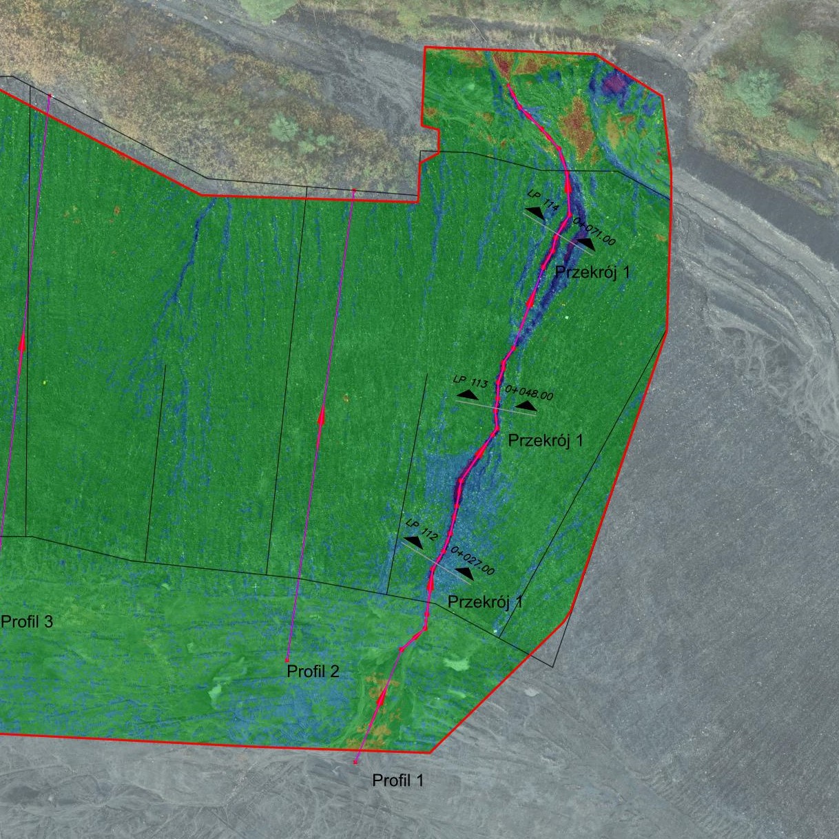
Cross-sections and projections
An interesting product for documenting building structures is the orthometric projection.
It is a fully cartometric representation of a specific plane, e.g. a façade, a building front, an acoustic screen or a retaining wall. Saving to a TIFF file enables us to review an object in high resolution. Depending on the Client’s wish, cross-sections may be saved to CAD (DWG, DXF) or PDF files.
Application: Creating a clear architectural and construction inventory (mainly for planned renovations).

3D modelling
3D modelling is a process in which we use software to transform a mathematical representation of an object into a 3D model. The created object is called a three-dimensional model used in branches such as mining, industry, construction or architecture.
3D modelling facilitates communication of ideas, is used to create interactive positioning of objects or surfaces that represent the actual design. It provides control of the real condition with design parameters. It allows us to create a part of a physical object in a very fast time, so we can make analyses of physical properties and then update the model as needed.
Available data formats are: DWG, DXF, DGN, STP and others. Models (solids) are created by us on the basis of a point cloud to maximally facilitate the Client’s work in such programs as AutoCAD Civil 3D, Inventor, Revit or Archicad. Processed buildings, machines or pipe networks give the possibility to work comfortably in the environment familiar to the designer.

Online application - sharing 3D measurements
Our company offers data sharing on platforms such as Sketchfab and Cloud PIX4Dcloud, as well as YouTube.
Sketchfab
Sketchfab is a platform that allows us to publish our 3D models online. It uses WebGl technology, thanks to which we can view or share our files without having to install any plug-ins in our browsers.
PIX4D cloud
PIX4Dcloud is an online platform for mapping data acquired from photogrammetric air shots, tracking progress and documentation. It allows us to create 2D maps and 3D models from the received images. It enables distance, area and volume measurements, as well as virtual inspections of the area of interest. It generates elevation profiles and allows us to share the results with stakeholders.

Realizacje
Geodetic as-built inventory of buildings
Szczegóły realizacji
A post-construction survey of roads, sidewalks, curbs, squares, paths, fences, sewage network, power grid including streetlights and signalization, telecommunication network, water supply network, gas network, and development of survey results to create a geodetic map of the post-construction inventory of building structures on the Gliwice bypass.
Photogrammetry for mining
Szczegóły realizacji
The low-altitude aerial photogrammetry technique was used to carry out the task, utilizing non-metric photographs.
The technology involves processing digital images into a 3D point cloud, which is a spatial, finite representation of the terrain consisting of points with X, Y, Z coordinates and the color values of each point (pixel).
Photogrammetric and laser scanning with 3D thermal measurements
Szczegóły realizacji
The laser scanning technique was used to carry out the project, which involves collecting a significant amount of points (several million points per station) within the range of the laser scanner.
In addition, a thermal imaging camera was used as an overlay, allowing for temperature data to be collected in addition to the point cloud data. 14 scanner stations were set up in the field to complete the project.
The 3D thermographic measurements were carried out using photogrammetry and laser scanning techniques on a mining waste dump
Szczegóły realizacji
The aim of the research conducted in this project is to locate the combustion zones and determine the intensity of thermal phenomena occurring within the coal waste dump located in the area of Magdalena Street in Bytom.
Research scope:
- Low-altitude photogrammetry with the use of an unmanned aerial vehicle (UAV) within the surveyed area
- Laser scanning of the landfill combined with infrared temperature measurement within the thermally active area
- Processing the point cloud data to create a geometric representation of the surface of the landfill site along with a temperature distribution map
- Measurement of internal temperature (depth of 1.0 m) of the landfill in selected points
- Measurements of gas concentrations (O2, CO2, CO, CH4) inside the landfill atmosphere
- Interpretation of the obtained research results
Analysis of erosion of the slope of the spoil heap at the Janina Mining Plant.
Szczegóły realizacji
Analysis of erosion on the slope of the waste dump at the Janina Mining Plant based on aerial photogrammetry and terrestrial laser scanning.
The results of calculations based on low-altitude photogrammetry were then compared with measurements using terrestrial laser scanning (TLS). Differences in volume between the first and last measurement sessions were compared for each measurement technique.
Nalot fotogrametryczny w celu planowania prac konserwatorskich
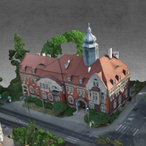
Szczegóły realizacji
W 1902 roku w Mikulczycach powstał ratusz gminny. Budynek został wzniesiony z cegły, na planie prostokąta, w stylu eklektycznym z wieloma elementami secesyjnymi. Bryła jest wzbogacona o ryzality z loggią i wykuszem oraz szczytem o falistych spływach, mansardowym dachem. Reprezentacyjności dodaje gmachowi ośmioboczna wieżyczka, przykryta cebulastym hełmem. Kamienne obramowanie drzwi i okien nadają budowli akcent secesji. Pod koniec lat 30. ratusz gminny uległ przebudowie, następnie mieściła się w nim przychodnia lekarska a obecnie jest on ponownie remontowany.
Na potrzeby planowania prac konserwatorskich został wykonany lot fotogrametryczny dronem. W procesie przetworzenia pozyskanych zdjęć uzyskaliśmy model 3D, który można zobaczyć na platformie Sketchfab:
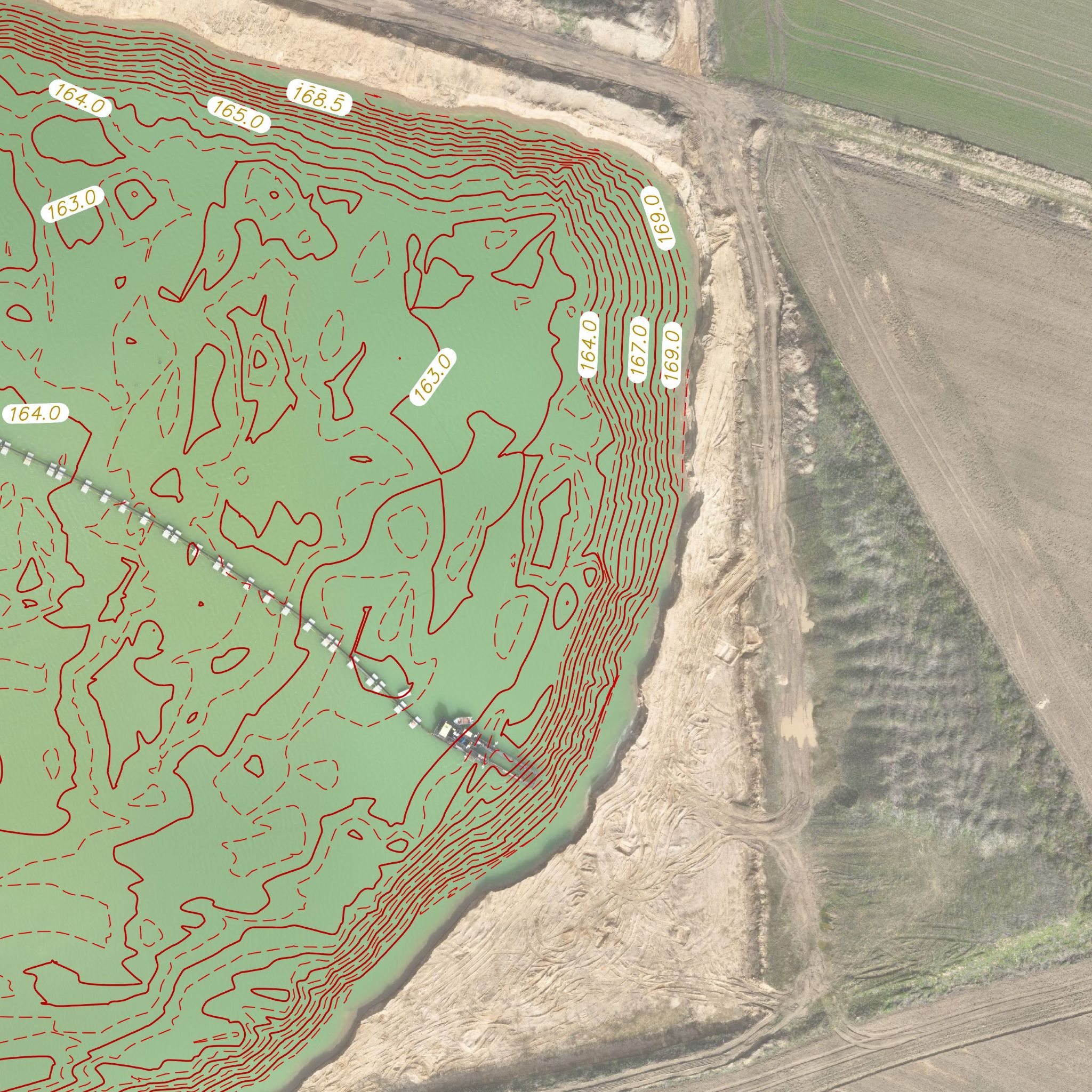
Bathymetry for mines
Szczegóły realizacji
Bathymetric surveying is performed for open-pit mines to determine the depth and shape of existing water reservoirs. Many open-pit mines have large water reservoirs that are used for a variety of purposes, including cooling machinery and equipment, protecting against fires, or collecting water for industrial purposes.