Services for industry and architecture
Innovative surveying technologies - applied in industry and architecture, enable us to provide our clients with high, modern level of services.
Long-term cooperation with companies which appreciate the effects of our work and individual, flexible approach to each task confirm the quality of our services.
Architecture
Thanks to the use of 3D laser scanning or photogrammetry we obtain visualisations of details both from the outside and from the inside of an object. Performing scans of an object in combination with architectural knowledge allows us to perform an inventory at a level of accuracy and detail unattainable for classical field measurements. By creating parametric models we make full 2D architectural and construction documentation, 3D models serving as a basis for the reconstruction or renovation project (including BIM models), examination of deformations occurring or accurate surface and volume measurements of objects. Thanks to 3D model visualization, we have the ability to create the so called virtual tour, which can be an important element of the presentation for an investor.
Architectural applications
- Full architectural and construction documentation, including elevation projections, cross-sections
- Surveying the condition of historic buildings - including the identification of cavities, damage, etc. using drones or thermal imaging cameras
- Verification of the planned investment - investigation of collisions between the planned and existing infrastructure
- Documenting construction progress
- Construction management using modern BIM techniques
- 3D modelling of buildings
- Deformation analysis of objects
- Virtual tours around the facilities
- Inventory of interiors and details of buildings
See completed projects
Ask a question
Industry
The category of industrial surveys requires great precision and accuracy of the conducted measurements, therefore the combination of the tasks of engineering land surveying and modern surveying techniques ensures the best quality of services.
Our company provides the classical service with the required standards or specifications, as well as using remote sensing methods transferring the infrastructure of land surface and objects to the digital model. Using drones or a laser scanner, we obtain results on the level of accuracy and detail required by a given industrial plant.
Surveying of objects using 3D laser scanning technique is an extremely accurate and fast way to perform non-invasive, safe measurement and smooth exit from the site. This technique allows us to obtain three-dimensional data of the environment in a very short time which significantly speeds up investment processes. We offer our services in the field of surveys for industrial facilities such as: manufacturing plants, chemical plants, automotive plants, power plants, steel mills always ensuring that the technological requirements of the client and even the most demanding safety and health rules are met. High accuracy of measurements allows us for obtaining comprehensive information on the shape and location of objects, and the tools, which we provide after the measurement, allow us for comfortable work on point clouds or 3D models and effective viewing of the results.
As part of our service delivery we provide, among other things:
- Dedicated measurement reports and specialised analyses
- Online consultations after the measurement service
- Sharing point clouds or 3D models with external online or desktop software
- Comparison of a given object to the designed state with visualization of differences
- CAD solid model
- Cross-sections and projections
- Calculations of volume, area and length
- High resolution images
- Point clouds
- 3D model with texture (so-called mesh)
- Orthophotos
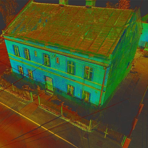
- Thermographic analyses
- Point cloud fly-through visualizations
- Numerical field model
- Video documentation
- 3D modelling
- Construction management using modern BIM techniques
- Verification of creation of a structure comparing to the design
- Check progress of construction works
- This is also an interesting idea for a page element
- The possibility to measure even hard-to-reach, remote places
Our products
As a result of appropriate data processing, we can offer several products - both for full 3D and classic 2D work. These are, among others, orthophoto-maps, projections, cross-sections, longitudinal profiles and various thematic maps.
Point cloud
A point cloud is a multi-million point set that is a geometric representation of a scanned object.
Clouds are acquired either indirectly (photogrammetry) or directly (3D laser scanning). There is a possibility to provide a cloud that is a combination of both technologies, which allows for full imaging of a scanned object.
Point clouds are usually so dense that they appear to form a continuous surface. The density of a point cloud depends on the class of scanner, its accuracy settings, and the distance from the object being scanned. Each point has a colour assigned to it, which makes it easier to identify the reconstructed objects in the cloud. Unlike the photogrammetry technique, the acquired point cloud has a scale, so measurements can be performed on it immediately without the need for fitting.
Upon client’s request, the cloud is provided in Polish Coordinate System 2000. Available data exchange formats include: LAS, LAZ, PLY, XYZ, RCP and RCS. Point cloud can be conveniently viewed and measured in Autodesk Recap software. Additionally, it can be loaded into AutoCAD, Microstation, Cyclone or ArcGIS software.
Application: Design, architectonic, visualization and planning purposes

3D model with superimposed texture
3D model with superimposed texture: OBJ, STL, PLY, FBX and 3D PDF.
It is possible to load the file into programs such as Revit, Inventor, Meshmixer, Infraworks, 3D Studio Max and Sketchup and print it on a 3D printer.
Application: Visualization and planning purposes

Orthophotos
Orthophoto-map is a cartometric image acquired as a result of processing a photo taken by an unmanned aerial vehicle (BSP, drone). It is a comprehensive source of knowledge about a given space.
The image obtained from the drone is characterized by a high resolution of the field pixel (at the level of 1 cm), which allows us to identify even the smallest elements of the infrastructure. In contrast to the aerial photo, orthophoto-map has a uniform scale for the entire surface of flat field. The use of drones in surveying work enables the preparation of an orthophoto-map of a given area even of several hundred hectares. The product is georeferenced which makes it possible to read the map in the appropriate software and to make the project and add resources in the form of the basic or register map.
It is possible to load maps with accurate georeferencing into such programs as AutoCAD Map 3D, AutoCAD Civil 3D, Microstation and ArcGIS.
Uses: spatial planning, land registry modernization, environmental analysis, designing construction works, site visualization, detecting changes in the natural environment, creating documentation of natural disasters, quality control of maps and cartographic data

Numerical land coverage model
Numerical coverage model provides precise representation of the existing field, which generates a wide range of possibilities for analysis, comparison, calculation, design and spatial planning.
The available formats are: GEOTIFF, XYZ, LAS and LAZ. It is possible to import the file to AutoCAD Map 3D, AutoCAD Civil 3D, ArcGIS and Microstation.

Videos and photos with editing
Tworzymy filmy w dowolnej jakości – nawet do 4K. Dokumentacja video pozwala na precyzyjną inspekcję
We create films in any quality - even up to 4K. Video documentation allows for a precise inspection of a specific element. We also offer visualisations in the universal MPEG4 (MP4) format which enables a comfortable presentation of an object to a Client, investor or supervisory inspector. We offer taking a very large number of photographs (from several dozen to several thousand - depending on the size of an object) with a resolution of up to 36 MP.
The photos are in a customized format.
Application: Very detailed documentation of an object and its changes over time
We deliver films in MP4 or AVI format.
Application: Very detailed documentation of a specific component

Calculations of volume, area and length
The information is supplemented by an appropriate graphical presentation, authenticating the calculated value.
We use low-altitude aerial photogrammetry technique with the use of non-metric images. The technology involves processing digital images to a 3D point cloud, which is a spatial, finite representation of field consisting of points with coordinates X, Y, Z and the colour value of each point (pixels).
In order to calculate the volume of earthworks, we create numerical field models in the form of TIN (Triangulated Irregular Network) grid in AutoCad Civil 3D software.
The computational task is to compare the created numerical field models (TIN meshes). The difference between the 3D surfaces is obtained and then the values of excavations and embankments between the models are calculated.

Cross-sections and projections
An interesting product for documenting building structures is the orthometric projection.
It is a fully cartometric representation of a specific plane, e.g. a façade, a building front, an acoustic screen or a retaining wall. Saving to a TIFF file enables us to review an object in high resolution. Depending on the Client’s wish, cross-sections may be saved to CAD (DWG, DXF) or PDF files.
Application: Creating a clear architectural and construction inventory (mainly for planned renovations).

3D modelling
3D modelling is a process in which we use software to transform a mathematical representation of an object into a 3D model. The created object is called a three-dimensional model used in branches such as mining, industry, construction or architecture.
3D modelling facilitates communication of ideas, is used to create interactive positioning of objects or surfaces that represent the actual design. It provides control of the real condition with design parameters. It allows us to create a part of a physical object in a very fast time, so we can make analyses of physical properties and then update the model as needed.
Available data formats are: DWG, DXF, DGN, STP and others. Models (solids) are created by us on the basis of a point cloud to maximally facilitate the Client’s work in such programs as AutoCAD Civil 3D, Inventor, Revit or Archicad. Processed buildings, machines or pipe networks give the possibility to work comfortably in the environment familiar to the designer.

Online application - sharing 3D measurements
Our company offers data sharing on platforms such as Sketchfab and Cloud PIX4Dcloud, as well as YouTube.
Sketchfab
Sketchfab is a platform that allows us to publish our 3D models online. It uses WebGl technology, thanks to which we can view or share our files without having to install any plug-ins in our browsers.
PIX4D cloud
PIX4Dcloud is an online platform for mapping data acquired from photogrammetric air shots, tracking progress and documentation. It allows us to create 2D maps and 3D models from the received images. It enables distance, area and volume measurements, as well as virtual inspections of the area of interest. It generates elevation profiles and allows us to share the results with stakeholders.

Realizacje
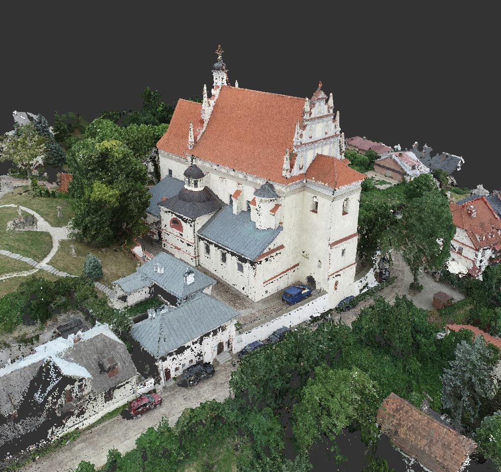
Architectural and construction inventory based on laser scanning
Szczegóły realizacji
Thanks to the use of modern measurement techniques, such as laser scanning, we can quickly and accurately obtain measurements of building objects.
Then, using modern software, we can create plans and sections of the measured building objects, obtaining architectural and construction documentation.
Geodetic as-built inventory of buildings
Szczegóły realizacji
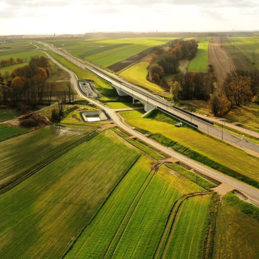
A post-construction survey of roads, sidewalks, curbs, squares, paths, fences, sewage network, power grid including streetlights and signalization, telecommunication network, water supply network, gas network, and development of survey results to create a geodetic map of the post-construction inventory of building structures on the Gliwice bypass.
Airport reconstruction and expansion
Szczegóły realizacji
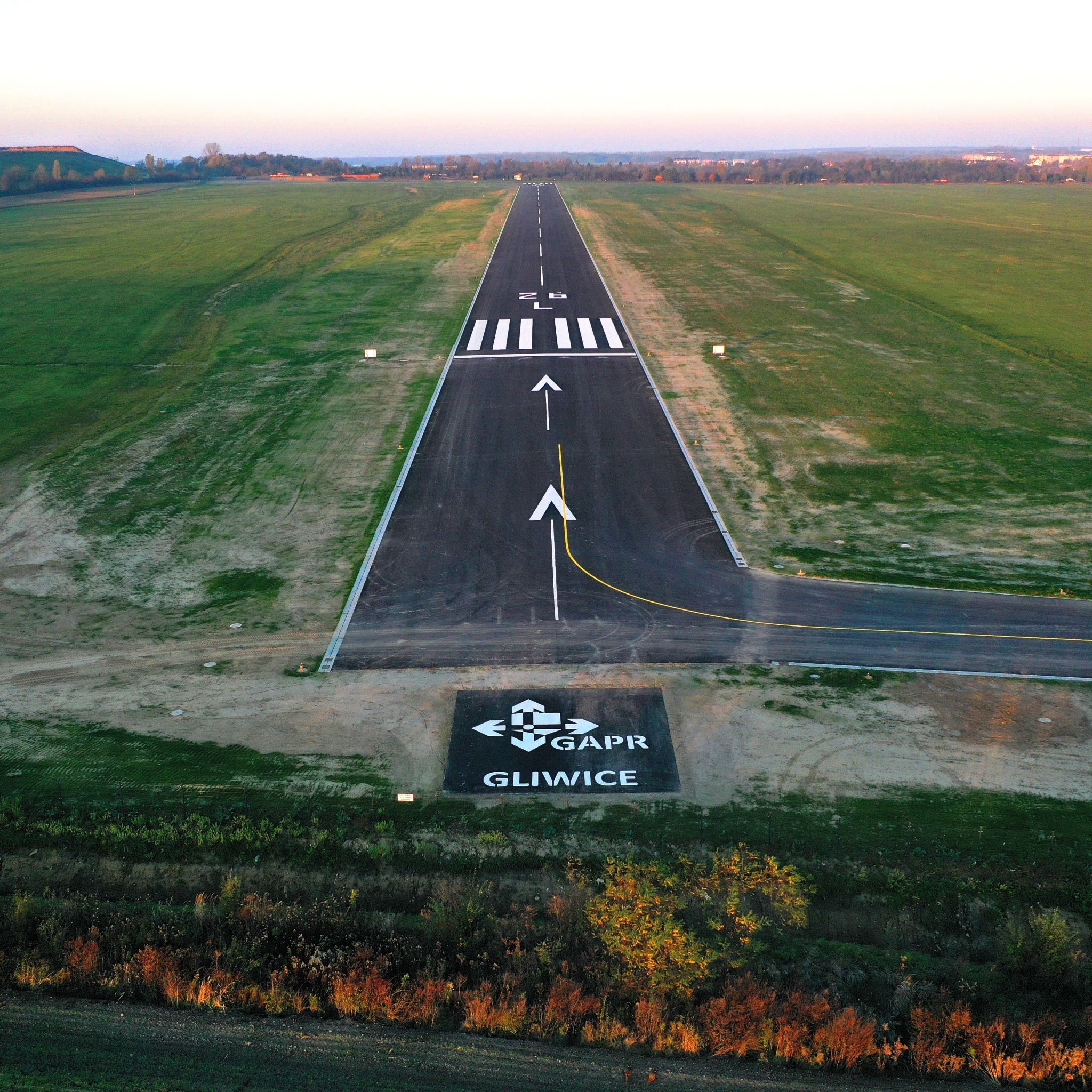
Using traditional surveying methods, our company supervised the implementation of an investment project involving the reconstruction and expansion of an airport in Gliwice.
The first stage included adapting it to the needs of exclusive airport use with reference code 1B (with the possibility of transformation to 2B) along with the construction of necessary technical infrastructure and the fuel system.
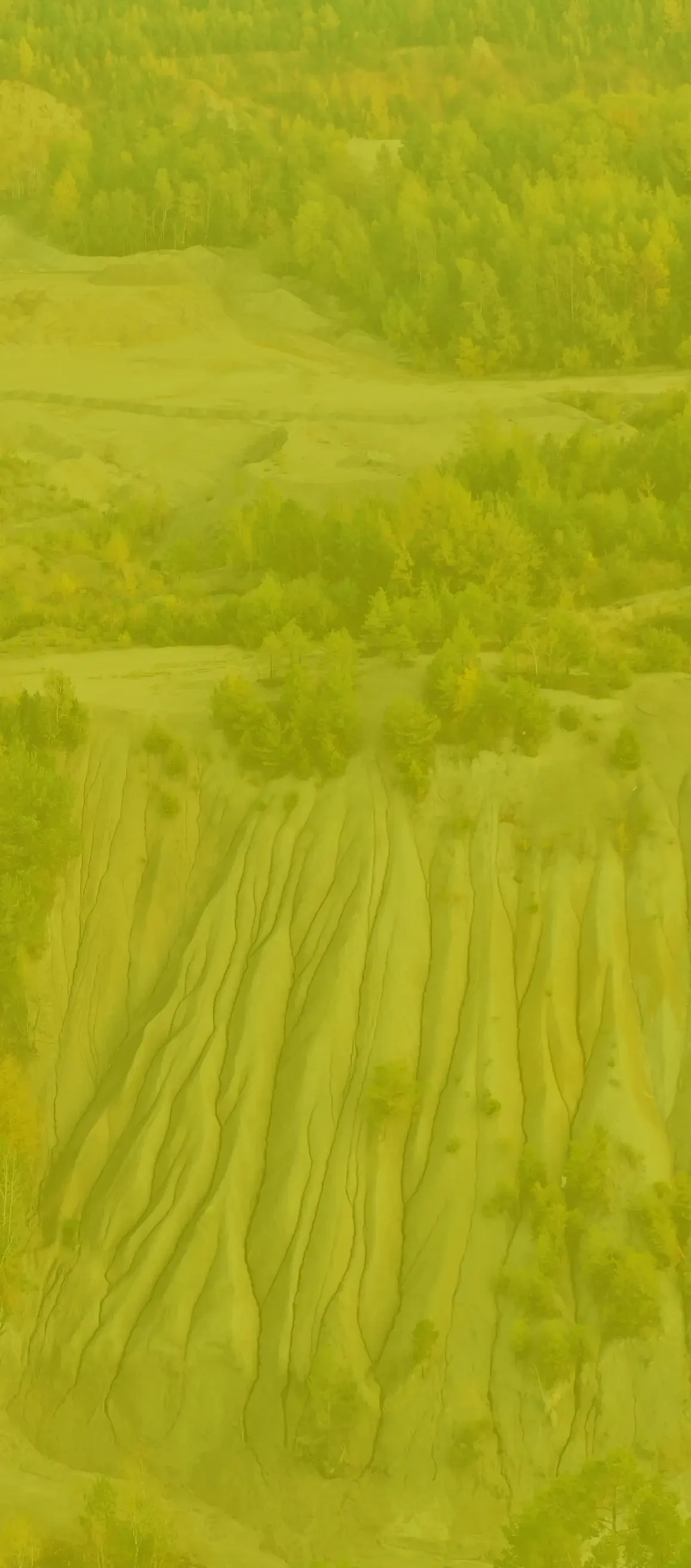
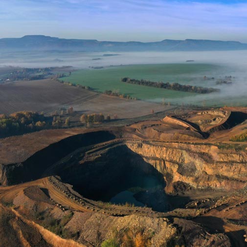
Photogrammetry for mining
Szczegóły realizacji
The low-altitude aerial photogrammetry technique was used to carry out the task, utilizing non-metric photographs.
The technology involves processing digital images into a 3D point cloud, which is a spatial, finite representation of the terrain consisting of points with X, Y, Z coordinates and the color values of each point (pixel).